Image © Copyright Tom Knapp and licensed for reuse under this Creative Commons Licence
The Lolly mine is situated on the southwest bank of the River Nidd, ¾ miles south-east of Lofthouse, near Pateley Bridge in Yorkshire. The location is at NGR SE10747248, at an altitude of 550 feet AOD.
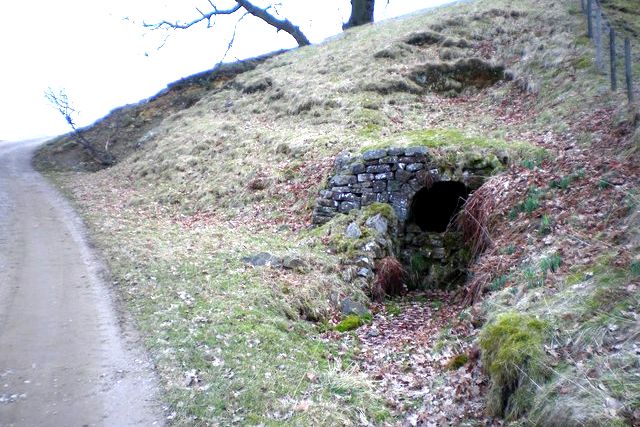
The main crosscut was driven for 550 feet due south, through the Basal Grits, to the Lolly vein. The crosscut was commenced in 1866 but stopped soon afterwards. Driving restarted in 1889; the portal bears the date July 1895 and this may be an indication of the lease being taken up by Joseph Cradock of Stockton-on-Tees. Cradock was the chairman of the Old Gang Co. in Swaledale, who on the closure of the latter, redeployed a number of his men to Lolly Scar. Edward Cherry of Fremington was employed as agent. It is said that Cradock employed the bing system at the mine until as late as 1904.
Lolly vein runs east-west and has been worked over a distance of 4,400 feet. It has an average width of 3-4 feet, is vertical in the thick bedded grits, and nips down to a joint with little traces of mineral, in the thin overlying grits and shales. Vein minerals present are amber fluorite, barytes, calcite, witherite, blende and galena. The vein has only been followed into the limestones at one point: this is at the forehead of the Horse Level, where the limestone was 21 feet below the level sole. This trial was made in 1904 and as no further work was done, it is presumed that the vein as barren of lead and not promising.
Between 1898 and 1904 the average output of lead was 450 tons per year but in 1906 this figure had dropped to 65 tons and seems to have continued until closure in 1910.
In 1904 development of a parallel south vein, via John Peacocks and James Walkers Crosscuts was recommenced, this vein having been found in 1901. A number of rises and sumps were put-in and it is probable that most of the mines later output was from this vein. Two crosscuts were pushed further south without success and were stood in 1905.
In 1901 Bents New Level was driven from the east bank of Blayshaw Gill at NGR SE095725 at 775 feet AOD. This crosscut was driven southeast in the thin grits and plate for 950 feet to the Lolly vein. A drift was put in, 300 feet eastwards, and a sump connected with the Top Durk Drift from Lolly Scar Mine on 4th June 1903.This level appears to have ceased development in 1904 and was abandoned in 1910. A seven-inch coal seam with associated fire clay and ironstone bands is found in the Crosscut and a 1½ inch seam occurs 24 feet lower. None of these were worked from the level but a dump of iron slags can be seen further up the Gill.
Cradock’s company tried numerous parallel strings near to the Lolly Scar mine. The most well developed being Silver Hill vein, the level being driven from NGR 10287272 at an altitude of 590 feet AOD. The crosscut was driven due south through the grit for 165 feet to the Silver Hill vein. This east-west string is vertical and consists of 3-4 inches of barytes with some calcite. Some limited stoping has been done and a six foot deep sump, put down. The crosscut was commenced on 3rd March 1905 and closed after 240 feet of drivage along the vein, in January 1908, being abandoned in 1910.
Joseph Caygill’s Hand Level was started on 7th July 1906 to work an east-west string from NGR SEl0687256. It was closed in November 1906.
For further details please see British Mining No 60 – The Greenhow Mines by MC Gill
Return to previous page