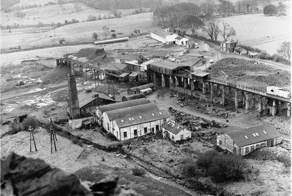
Deerpark Colliery taken from the top of the waste heap
Used with kind permission from Firoda National School
The Castlecomer Plateau, in counties Carlow, Kilkenny and Laois, is in part an outlier of Wesphalian measures. It has three divisions. The lowest, the Moyadd Coal Formation, is overlain by the Clay Gall Sandstone Formation, which is overlain by the Coolbaun Formation. The strata dip gently towards the centre of the plateau to form a basin-like structure.
There are at least eight coal seams, all of them anthracitic, but not all of them have been worked. The No.2 or Marine Band seam, in the Moyadd Coal Formation, is the most widespread and economically important. It is 12 inches thick, and was worked extensively in the east and north-east part of the coalfield, but was absent from most of the coalfield south of the Coolbaun Fault. In the western part of the coalfield it splits into two leaves, with the lower one called the Skehana seam. This was a high-grade anthracite, with low sulphur content, and was extensively worked by Deerpark colliery.
The remaining coals, in the Coolbaun Formation, in ascending order are: Wards (8 to 12 inches), the Jarrow (9 to 12 inches) and the Three Foot (36 inches). Another three seams were too thin to work.
Mining dates from at least the early 17th century when the Wandesforde family, local landowners, opened pits into the Three Foot Coal in the central coalfield. With the seam nearing exhaustion by 1815, exploratory shafts discovered the Jarrow seam, at a depth of around 245 feet, near Clogh.
In the twentieth century, the Skehana seam was discovered at Skehana and in 1924 Deerpark colliery was sunk to work it. This was the largest mine and it worked until 1969, but there were also Kilgory (1948-1952) and Flemings 1940-1965. In the 1970s some opencasting was done, and there was a small mine at Rossmore.
Traces of heaps from shallow shafts can be seen throughout the coalfield, and at Holly Park there is a well-preserved chimney. Some buildings also survive at Deerpark.
Further information:
- Irish maps viewer
- Leinster Coalfield District Report
- Coal Mining in Castlecomer
- NMRS online mapping of the collieries of the British Isles

