This is an interactive map, point to a location with your mouse to see basic information, click to go to that page.
See also Jet Mining
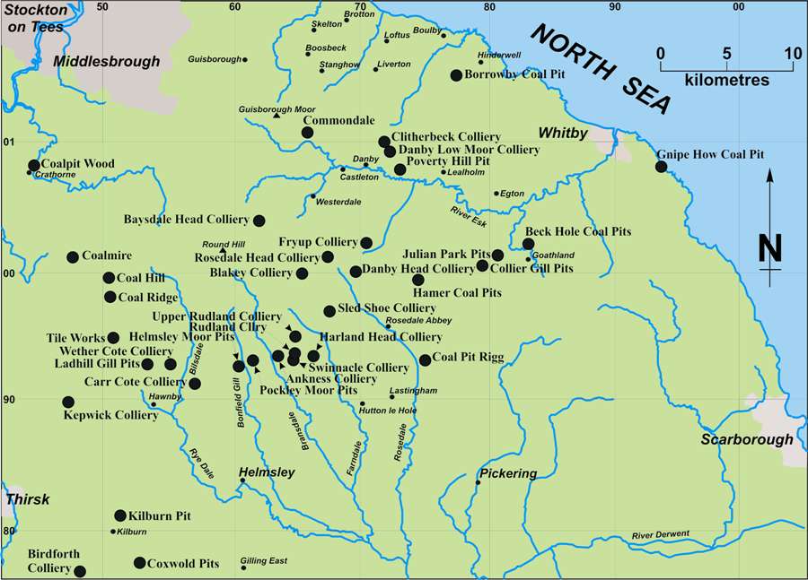
Collieries not shown on the map:
May Beck and Allen Tofts Pits, Sneaton and Eskdale cum Ugglebarnby.
Snilesworth Colliery, Hawnby.
The region is a very clearly demarcated block of high land, bounded on the western edge by a steep escarpment, and on the east by sea cliffs. To the south, the Tabular Hills dip gently to the south and east, but there is a distinct change in slope where the land drops down to the Vale of Pickering. The core of the region is a gently undulating plateau, incised by steeply-sided valleys and with an average elevation of around 1000 AOD. Its highest point, Round Hill, reaches 1490 feet AOD. The underlying Middle Jurassic Ravenscar sandstone and mudstone have given rise to acidic, peaty soils. The area is drained by wet flushes, springs and small gills, leading to steep-sided dales, which drain radially.
Coal seams, with an underlying seat-earth, are not uncommon in the Middle Jurassic strata, but most are very thin. Some are little more than a carbonaceous shale, and some are of only a limited extent. Like seams in the Dales, however, they formed on an active palaeo-surface of river channel^ sand banks, flood plains and lagoons, in which coal swamps formed on sand or mud substrates, so it is possible for seams to be broadly coeval, but not necessarily conjoined Where worked, the coals were usually between 6 and 22 inches thick, though thicknesses of 4/4 inches were sometimes taken1.
Although often referred to without discrimination as the ‘Moor Coal’, there are workable seams, which occur at three broad horizons in the Saltwick Formation, below the Moor Grit. These horizons are at:
- Around 3 metres above the base of the Saltwick Formation (Dogger).
- Around 20 metres above the base of the Saltwick Formation (Dogger).
- 16 to 32 metres below the base of the Scarborough Formation.
- North Yorkshire County Record Office (NYCRO) ZEW IV 13/1. Memorandum of the collieries the property of C.S. Duncombe in the year (1786 to 1801) also the Variable and Mean thickness of the Seam of each Place separately – by D. Seaton. This is a series of annual valuations, from 1786 to 1801, which have been tabulated for each individual colliery. This places the seams on either side of the junction between the Aalenian and Bajocian ages, where they formed between 172 and 169 million years ago.
Most of the coal pits are in an east-west belt, running 20 km. south from the north side of Eskdale and 30 km. west from the A169 road, which runs south from Whitby. The principal collieries, around Rudland Rigg and the head of Rosedale, worked the last of the above seams extensively. Other pits are found in the Hambleton Hills, near Coxwold to the east of Thirsk, at Crathome, and on the coast near Whitby.
In the north of the region, coal was sometimes encountered while sinking shafts at ironstone mines. For example, the shafts at Kilton cut the following two seams, which were left unworked:
- 5 inches at 143 feet above the Alum Shale,
- 6 inches at 233 feet above the Alum Shale.
As with the Dales, almost all the early references to coal mining in the area come from the work of geologists. As early as 1813 William Smith reported on a coal mine near Whitby, and in 1821 Winch gave details of borings for coal around the head of Baysdale (Hemingway and Owen, 1975; Winch, 1821). Fox-Strangways (1892) also recorded the coal in his monograph on Yorkshire’s Jurassic Rocks. In 1938 two members of the Coal Survey Laboratory published a paper comparing an analysis of the Jurassic Coal from near Baysdale Head, with the average of four pillar sections of the Yorkshire coalfield’s Warren House seam and a sample of Tan Hill Coal (Wandless and Slater, 1938).
The Baysdale Head sample, from a ten inch seam, was described as a fragile bright coal, freely interstratified with thin shale partings. It was well-banded, with abundant vitrain and some fusain, though of relatively low rank (69.4 per cent carbon in a cleaned sample). Its ash content was 14.9 per cent. Being a lignitious coal, dominantly made from Equisetites (horsetails) stems, it had a lower rank than the others, was non-coking and left a powdery residue. In contrast, Hemingway reported that samples from pits at Rosedale Head and Rudland Rigg were of medium volatile rank, with reflectivities of 0.87 and 0.82 per cent respectively, which is higher than that for coal from the nearby south Durham coalfield. He ascribes this to the strata of the Cleveland basin having originally being buried at much greater depths, therefore enhancing the coalification process by subjecting the coal to great temperatures and pressures, before being forced upwards into a dome, in a process known as basin inversion (Hemingway and Riddler, 1982).
The Tan Hill coal was a compact bright coal, containing very little visible impurity. It was a mature coal, of relatively high rank, and was strongly coking, producing a highly swollen coke on carbonisation. The Warren House coal was of intermediate rank and had a higher sulphur, chlorine and carbonate content than the other two. The ash content of the Tan Hill and Warren House coals was 2.7 and 4.3 per cent respectively.
The most striking difference between the three coals was in the composition of their ashes, however, as shown below.
| Analysis of Ash | Jurassic | Tan Hill | Warren House |
| SiO2 | 46.37 | 49.97 | 24.58 |
| TiO2 | 1.87 | 0.82 | 0.75 |
| Al2O3 | 36.80 | 41.53 | 15.57 |
| Fe2O3 | 6.04 | 3.80 | 31.75 |
| CaO | 2.95 | 1.29 | 10.24 |
| MgO | 1.59 | 1.02 | 1.03 |
| P2O5 | Trace | 0.55 | 0.16 |
| SO3 | 1.73 | 0.48 | 8.75 |
| Mn3O4 | Trace | Trace | Trace |
| Difference | 0.65 | 0.47 | 7.17 |
The most variable constituent of coal ash is iron, expressed as Fe2O3, which commonly ranges from about 10 per cent to over 70 per cent in some cases. Both the Jurassic and Tan Hill samples had very low iron contents (3.87 per cent and 6.04 per cent respectively), together with high silica contents and very high alumina contents. As a result, the composition of their ash approached that of an aluminous fireclay, which contrasted very strikingly with the ash from the Warren House and other seams in Yorkshire.
Hemingway’s section on the Jurassic period in The Geology and Mineral Resources of Yorkshire gives a good description of the processes which formed the North Yorkshire Moors and has a brief discussion of the Middle Jurassic coals (Rayner and Hemingway, 1974). Just before the latter volume appeared, interest in the subject had begun to grow amongst industrial archaeologists and, in 1969, John Owen published the first of three papers on “The Moor Coal” in the Cleveland & Teesside Local History Society’s Bulletin (Owen, 1969, 1970a and b). Owen’s first paper was quickly followed by Barry Harrison’s examination of the Business and Social History of the Danby Coalmines, in Eskdale, and Arthur Whitaker’s study of the Bransdale and Farndale coal mines (Harrison, 1969 and Whitaker, 1969). There was also a short section on coal mining in the Historical Atlas of North Yorkshire (White and Harrison, 2003)
Return to previous page