 |
Northern Mine Research Society Registered Charity 326704 |
Other Mines of the British Isles
The database behind this mapping began life as a paper index of sites in the Northern Cavern & Mine Research Society Records in the early 1960s. It was digitised, in dBASE III format, in the late 1980s and is now held in Access and contains a wide range of information. The Northern Mine Research Society is pleased to make this valuable tool freely available to anyone interested in mining history.
Please note that sites are recorded as point data, but it must be remembered that some occupied larger areas.
Mike Gill - NMRS Recorder
Acknowledgements
No project like this can be completed without help from a wide range of individuals, and over fifty years many people have contributed data, much of it from NMRS publications. This part of the database is, by far, the least well developed and represents an area ignored by many mining historians.
This sections includes evaporate minerals which formed where seas and lakes have evaporated, causing higher salinity, more quickly than they are replenished. They include Rock Salt, Gypsum and Potash.
Further reading:
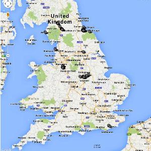
The maps are offered in both 2D format using Google Maps and 3D format; however you must have Google Earth installed on your computer to use this. The Google Earth files are slower to load and run than the 2D maps version, however both contain the same data. Point to and click on a marker to see details of that site.
Please note that sites are recorded as point data, but it must be remembered that some occupied larger areas.
Mike Gill - NMRS Recorder
Acknowledgements
No project like this can be completed without help from a wide range of individuals, and over fifty years many people have contributed data, much of it from NMRS publications. This part of the database is, by far, the least well developed and represents an area ignored by many mining historians.
This sections includes evaporate minerals which formed where seas and lakes have evaporated, causing higher salinity, more quickly than they are replenished. They include Rock Salt, Gypsum and Potash.
Further reading:
- Landless, V. 1979 "Preesall Salt Mines", British Mining No.11, pp.38-43
- Tyler, I. 2000 Gypsum in Cumbria: A History of the Gypsum and Anhydrite Mining in Cumberland (Keswick: Blue Rock Publications)
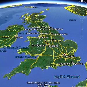
The maps are offered in both 2D format using Google Maps and 3D format; however you must have Google Earth installed on your computer to use this. The Google Earth files are slower to load and run than the 2D maps version, however both contain the same data. Point to and click on a marker to see details of that site.
Maps version |
 |
|||
Earth version (slower) |
 |