 |
Northern Mine Research Society Registered Charity 326704 |
Iron Mines of the British Isles
The database behind this mapping began life as a paper index of sites in the Northern Cavern & Mine Research Society Records in the early 1960s. It was digitised, in dBASE III format, in the late 1980s and is now held in Access and contains a wide range of information. The Northern Mine Research Society is pleased to make this valuable tool freely available to anyone interested in mining history.
Please note that sites are recorded as point data, but it must be remembered that some occupied larger areas.
Mike Gill - NMRS Recorder
Acknowledgements
No project like this can be completed without help from a wide range of individuals, and over fifty years many people have contributed data, much of it from NMRS publications. Nevertheless, I would like to thank John Ambler for sites on the Weald.
Especial thanks are due to: Matthew Town and Damien Ronan, of Northern Archaeological Associates Ltd, for converting files for use with Google Earth.
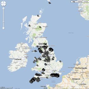
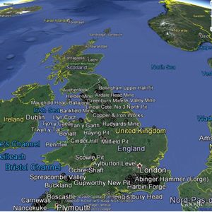
The maps are offered in both 2D format using Google Maps and 3D format; however you must have Google Earth installed on your computer to use this. The Google Earth files are slower to load and run than the 2D maps version, however both contain the same data. Point to and click on a marker to see details of that site.
Please note that sites are recorded as point data, but it must be remembered that some occupied larger areas.
Mike Gill - NMRS Recorder
Acknowledgements
No project like this can be completed without help from a wide range of individuals, and over fifty years many people have contributed data, much of it from NMRS publications. Nevertheless, I would like to thank John Ambler for sites on the Weald.
Especial thanks are due to: Matthew Town and Damien Ronan, of Northern Archaeological Associates Ltd, for converting files for use with Google Earth.
The maps are offered in both 2D format using Google Maps and 3D format; however you must have Google Earth installed on your computer to use this. The Google Earth files are slower to load and run than the 2D maps version, however both contain the same data. Point to and click on a marker to see details of that site.
Google Maps version |
Google Earth version (slower) |
 |
 |