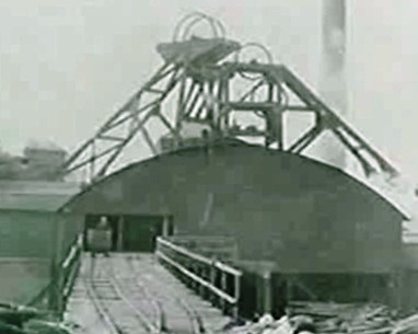
The headgear on the L is for the Lodge Pit shaft, sunk Jan 8th1840 – Jun 28th 1841 to 470 ft / 143.2 m just below the Busty Bank seam [1].
The headgear on the R is for the East Shaft sunk ?? to 438 ft / 133.5 m. The 1859 1:2500 OS County Series map shows both shafts, with the East Shaft being the smaller of the two. (Not to be confused with the East Pit, later renamed North Pit, which was located approx 64m N of Lodge Pit and sunk circa mid-1700s [2] ).
These two shafts were very close together and the colliery abandonment plans show a seperation of about 17 ft / 5.2 m (1953) to 25 ft / 7.8 m (1982) centre-centre [3].
1. An Account of the strata of Northumberland & Durham as proved by Borings & Sinkings, Volume L-R, North of England Institute of Mining & Mechanical Engineers, 1887
2. Strathmore Estate plan of Marley Hill shafts circa 1775 (Mine Records Office, Coal Authority)
3. Marley Hill Colliery Hutton (N) and Tilley (P) seam abandonment plans (Mine Records Office, Coal Authority)
On Google Earth’s historic imagery – year 2000, the concrete caps of both these shafts can be seen centred on 54deg 54′ 41.72″ N, 1deg 40′ 45.19″ W. The latest Google Earth image (2017) shows them completely covered by bushes but they should be easily found. Google Earth gives a distance of 6.11m/20ft centre to centre, with the East Shaft cap the smaller of the two.
On the M-H Colliery abandonment plans, the Lodge Shaft depth is given as 538.9 ft deep and the East Shaft as 438 ft – at the Busty seam level.
StefanT