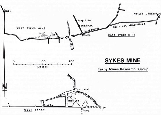
Two levels, one of either side of Losterdale Brook, have been driven along the Sykes anticline, which has limestone at its core and runs north eastwards to Whitendale. Faults, especially in the Lower Chert at the top of the Lower Limestone, are mineralised with: blende, galena, copper pyrites, malachite, fluorspar, barytes and quartz; calcite being rare. The principal vein is a fault which runs along the axis of the anticline.
In the quarry on the west bank, a 10 fathoms climb leads to an adit which was said to have been driven westwards, on the main vein, for some 126 metres. On the east bank of the stream, nearly opposite, another level has been driven north-eastwards for some 198 metres, again on the main vein. At 24 metres from its portal, this working intersected a cross vein and a shallow sump was put down.
The age of the workings is not known. Sykes is marked as an ‘Old Lead Mine’ on the 1857 Ordnance Survey map and disappears from later maps. In 1767, James Swale of Grassington raised enough ore at Sykes to make 12 cwt of lead when it was smelted at the Grassington Low Smelt Mill.
Fenwick Coulthard, a lead miner from Stanhope in County Durham, moved to the Newton by Bowland area around 1820 and lived there until the late 1830s. Given the apparent inactivity at Brennand in this period, it is likely that he could have worked at either Sykes or Ashnott. In 1839/40 his youngest son was born at Gisburn, where he may have been at Rimington, but he had moved to Malham by 1841. This may date the two levels at Sykes to the period 1820 to 1839.
For further information please see:
- Gill, M.C. The Yorkshire and Lancashire Lead Mines: A study of Lead Mining in the South Craven and Rossendale Districts (British Mining No.33, 1987)


