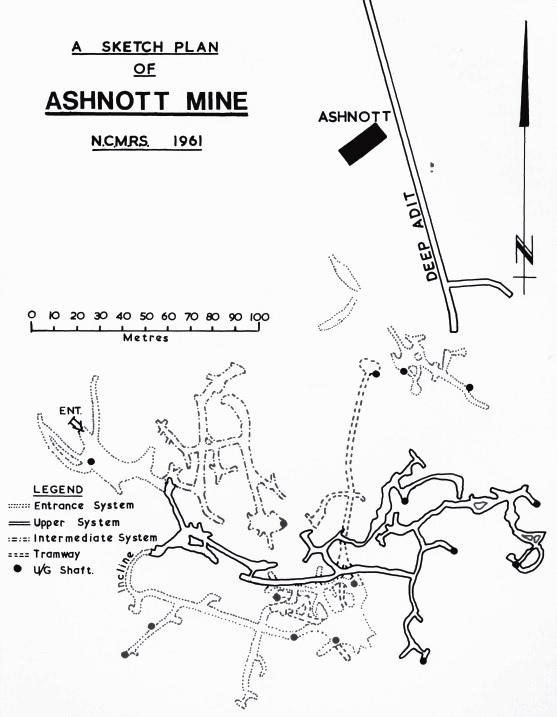
Plan of Ashnott Mine
From British Mining No.33 © MC Gill
This mine is in a limestone reef knoll, which forms the core of a complex anticline which is surrounded by members of the Worston Shale group. The mineralisation was in the form of irregular strings, and in the upper two horizons these were followed with the result that the mine, although of restricted extent, is complex. The lowest levels on the other hand are larger and had wooden rails with strips of iron on their running surfaces.
It is likely that the ramified upper workings, with their small hand-shafts and opencuts, are principally of seventeenth and eighteenth century date, but a lease in The National Archives, dated 1538, gave Thomas Proctor ‘licence to dig take & myne leade aeiore’.
The lower levels, with a more ordered system of haulage and layout, probably date from the 1820s, as does the adit driven from the stream side in Ashnott Wood. The mine probably closed during the major slump in the lead trade of 1830, and a report written in 1835, tells us that
“There is a lead mine within the manor, from which a considerable quantity of ore has been obtained, but it is not now wrought, in consequence of the depreciation in the value of lead. There is also a smelt mill near the mine, with an overshot waterwheel, and the requisite apparatus for smelting ore, and which mill etc. belongs to the Lord of the Mannor”.
The reference to the smelt mill being near the mine makes it highly likely that Ashnott is being referred to. At the time, the liberty belonged to Edward Peregrine Towneley, whose family had purchased the Lordship of the Manor from the Duchess of Buccleuch.
The first edition 1/10560 OS map for the area, surveyed in 1847, marks Ashnott as ‘Lead Mines’, which suggests that it was working. But, if so, it was a brief revival.
For further information please see:
- Gill, M.C. The Yorkshire and Lancashire Lead Mines: A study of Lead Mining in the South Craven and Rossendale Districts (British Mining No.33, 1987)
- Went, D. Ashnott Mine, Ribble Valley, Lancashire: An archaeological survey of the landscape evidence (English Heritage, Research Report Series No.74, 2014)